June 11, 2007
VCU’s urban studies and planning program recognized for bringing 'new dimension' to planning
Share this story
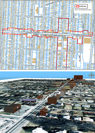
For many people, understanding planning or zoning issues means pouring through pages of static, color-coded maps, graphics and numbers. But some Virginia Commonwealth University graduate students won a national award for using computer software that adds a three-dimensional view to a plan, down to enabling the viewer to “walk down a street,” to see how it could impact the community.
The Information Technology Division of the American Planning Association presented its “2007 Best Use of Technology to Improve a Plan or Planning Process” award to the urban studies and planning program at the L. Douglas Wilder School of Government and Public Affairs.
“What we did was transform a plan from a two-dimensional perspective to a three-dimensional perspective, which made it more dynamic and easier to envision possible outcomes,” said Assistant Professor I-Shian (Ivan) Suen, Ph.D.
In the fall of 2005, graduate students in Associate Professor John Accordino’s urban commercial revitalization class developed a plan to revitalize Richmond’s Brookland Park Boulevard commercial district. While the plan was well-received in the community, it was difficult for students to show how revitalization efforts would change density and appearance along the corridor.
Scudder Wagg was one of the graduate students who developed the Brookland Park Boulevard plan and proposed creating a 3-D model of it while he was a student in Suen’s spring 2006 GIS (Global Information Systems) applications in decision analysis class. The plan was recreated in a virtual 3-D computer model using SiteBuilder 3-D in Scenario 360 (GIS software.)
“The 3-D model allows you to zoom in and out — actually walk along the sidewalk and see what’s proposed,” Suen said. “And that stimulates more public interest and understanding, which improves the planning process.”
VCU received the award April 16 during the annual American Planning Association Conference in Philadelphia. The recognition also included a $100 cash award which will be applied to a student scholarship fund.
Subscribe to VCU News
Subscribe to VCU News at newsletter.vcu.edu and receive a selection of stories, videos, photos, news clips and event listings in your inbox.