Dec. 13, 2023
Newly digitized maps at VCU Libraries offer a detailed look at 19th-century Richmond
Share this story
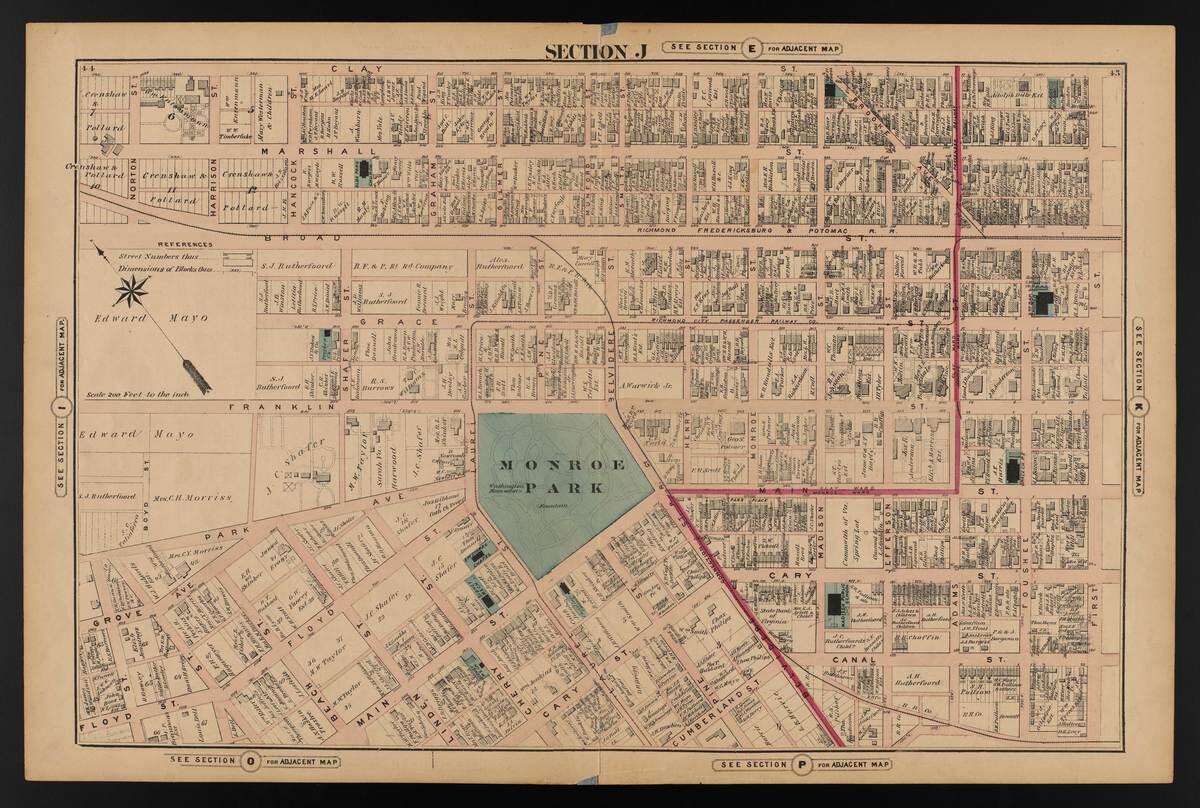
Offering a historic look at one of America’s most historic cities, a new VCU Libraries digital collection reveals the Illustrated Atlas of the City of Richmond, Va.
Also known as the Beers Atlas, the resource was published in 1876, barely a decade after Richmond’s business district near the Virginia Capitol was decimated by fire as the Civil War ended. Frederick W. Beers, from a family of cartographers, was a publisher of atlases and maps, and the Richmond atlas includes a table of contents, 21 maps, seven illustrations of businesses and eight pages of advertisers’ notices.
The maps offer insight into the state of the city – residential and commercial locales, architecture and infrastructure – some 20 years before the historic Jefferson Hotel was built and three decades after the Egyptian Building, now a landmark of Virginia Commonwealth University, was constructed as a medical college.
The original copy of the Beers Atlas is available in Special Collections and Archives. Exploring the digitized version, researchers can zoom in or out to enlarge images or narrow the focus to a particular view of elements. The images, which are free of copyright restrictions, are downloadable for use in presentations and publications.
The atlas shows a variety of buildings and structures, parks and green spaces, and places of worship. Waterways are highlighted in green. Property lines are detailed and often include the names of owners of many properties.
The Beers Atlas is a companion to the 1889 Baist Atlas. These two collections provide an opportunity to explore systemic racism found in the historical record of property lines, omissions and naming conventions, according to Irina Rogova, digital initiatives librarian.
“These maps, created decades before the Virginia General Assembly authorized racial segregation ordinances in 1912, offer insight into the built environment of Richmond following the Civil War as racial demographics shifted after the abolition of enslavement,” she said. “The maps provide a lot-by-lot look at neighborhoods that were transformed by redlining and urban renewal in the 20th century. Some of these neighborhoods today are undergoing development and change that can be characterized as preservation or gentrification.”
The two digital collections now live under a new Scholars Compass collection entitled City of Richmond Atlases and Maps.
Subscribe to VCU News
Subscribe to VCU News at newsletter.vcu.edu and receive a selection of stories, videos, photos, news clips and event listings in your inbox.